
The panorama above was meant to show the cool Giant Lobelia (lobelia deckenii) trees in the shadow of Kibo and the nice cloud formations. The false color is just a nice side effect of the process.

(Picture courtesy of UltimateKilimanjaro.com)
So, back to the climb... as you can see from the height profile map I posted previously, day 6 of the climb is ridiculously long. You start at 11PM at 15,430 feet at mile marker 24. From there, you climb for 10 hours to Uhuru Peak at 19,341 feet (and the longest four miles ever), climb down for 4 hours and 4 miles back to Kibo 15,430 feet, eat and take a nap for two hours, and then hike another 4 hours and 6 miles to Horombo Hut. Now, by the time we get back to Kibo Hut, we are pretty much walking zombies. However, a bit of food, oxygen, nap, and roughly downhill makes those 6 miles surprisingly easy.

As you can see, the first two miles are ridiculously flat, with Mawenzi just taunting us in the distance. That's Jonas and Modi in front of us. Ronald was still crazy sick by this point (although he did wake us up to tell us to pack - very nice and apologetically - thanks Ronald!), so Modi took over for him... except his English is bad, and he doesn't really know the trails. But he smiles a lot and is a nice dude.

Closer view of Mawenzi with clouds overhead providing interesting shadows.

Me basking in the glow of the descent, and William just wanting to get it over with. Spoil sport.

This is looking back at Kibo Hut. The clouds are really starting to come in now, and it has gotten noticeably colder without the sun and some wind has started to blow, which is a bit unusual considering we have had no noticeable wind on any part of the journey up to this point.


This is a closer view and a panorama view of trail threading between Mawenzi and the higher parts of the Saddle.

And this is the 360 panorama with both Kibo Hut and Mawenzi.

This sign makes more sense if you are ascending along the Marangu Route. For us, it was still nice to have markers, however, as the Rongai route strangely had a lack of signs. William is starting to feel like a person again.

After three days, we come back to the land of vegetation... or at least recently burned vegetation with black rocks.


One thing you will notice on this vegetation is hail. That's right, little ice crystals. I say it with a little bit of a grimace, because I had to greatly curtail my picture taking on the Saddle, because for a good hour of it, there was hail hitting us sideways. Just when I didn't feel headachey from the altitude anymore, the ice took over. Unfortunately, my jacket didn't have a hoodey, so I was reduced to turning my hat sideways to block most of the ice. It kind of worked, but my face still ended up crazy red and raw. Luckily, I was so tired and sore that it didn't really bother me that much.


This sign is also more relevant on the ascent. I guess this is where our porters went to get water at Kibo Hut. It was here that we ran into a bunch of people (Australians, I think) doing the ascent with ski poles. They were pretty tired, especially the ladies. They had worn a lot of layers and were getting warm, and so were contemplating taking some off. We warned them about the hail, however, and so they quickly decided that they could use the "extra padding" later on.

The circle in the distance is a helicopter landing pad. I guess after the crashed plane/helicopter we found on the Saddle, this was the closest they could get a helicopter safely, unless it was a true emergency. Every once in awhile, Ronald told us that people had to be airlifted off due to altitude sickness or other issues, which is also part of the reason the fees are so high - something like $7 each day goes to the rescue fee.

This was probably the last real uphill we came to, as the Saddle officially transitioned into moorland. We were not happy about it, but it was mercifully short.

I'm not sure why Resha is sticking her tongue out.


And we look back again at Kibo, now encased in the hail cloud, and how far we have come. Hard to believe we were at its base only like two hours ago.

The clouds are pretty magical at this point... and I am non-delirious enough to really enjoy it.

This is the first of the really tall Giant Lopelia trees we got close to. As you can see, I am doing my best California treehugger impression. It grows by the leaves at the top dying and then getting pushed lower while the new leaves on top keep growing.


The clouds broke a little toward Mawenzi, so we could still make it out in the distance.

But in our immediate surroundings, we entered treeland, which was a sight for sore eyes.

Me doing my thing.

Lopelia trees as far as the eye can see. Pretty cool.


We're getting pretty near Horombo Hut at this point, and as you can see, I still think people are crazy for wanting to go all that way to Kibo Hut from this point.
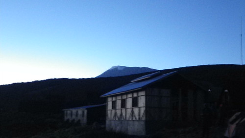
We finally reach Horombo Hut, which is actually a bunch of huts. But more on that next week.

For now, we watch the sun descend over the gentle slope of the mountain and the Tanzanian plane. Magical...
No comments:
Post a Comment